What is LUP4LDN?
LUP4LDN is a digital interface which integrates LDN into a participatory land use planning approach, allowing for a transparent and well-informed evaluation of land use and land management transition scenarios.
As a software analytics tool, it supports policy-makers, land use planners, land users, national and sub-national organisations and research agencies in understanding optimal and feasible SLM interventions for LDN, alongside crucial areas to focus land restoration efforts.
Where
is most crucial to focus land restoration efforts?
What
SLM interventions are optimal and feasible in order to achieve LDN?
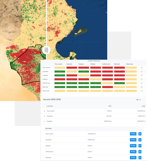
Inside LUP4LDN
The platform comprehensively interlinks existing tools such as the Global Geo-Informatics Options by Context (GeOC), the World Overview of Conservation Approaches and Technologies (WOCAT) SLM database, Trends.Earth and the Economics of Land Degradation (ELD) knowledge hub, including geo-spatial data on land cover, soil organic carbon, socio-ecological indices, and ecosystem services. It further allows users to see both visual and quantitative representations of LD gains and losses.
Designed as a ‘federated system’ – an open, collaborative and global network of independent data hubs equitably sharing information and knowledge relating to LDN, and as a monitoring tool supports users in achieving the relevant SDG 15.3.1 sub-indicators through analysing national and local data.
LUP4LDN was funded by a competitive grant from GEO-LDN. On behalf of the Jury Panel, Douglas Cripe, Senior Scientific Adviser at the Group on Earth Observation Secretariat, highlighted the achievements of the winning team during an online award ceremony in the margins of UNCCD CRIC19. “Of the tools presented, the LUP4LDN tool is the most innovative and the most directly responsive to the Competition’s challenge. LUP4LDN goes beyond analyzing data – it brings stakeholders together. It directly facilitates collaborative land use planning and the process guidance provided is applicable globally. We recognize the value of the tool in training land use planners toward embedding LDN in planning processes,” said Cripe.